
How to read this: Sumba Villa Investment is an independent investment-intelligence guide — we research, compare and explain Sumba land and villa opportunities, then route serious enquiries to a vetted partner. We are not a broker, developer, financial adviser, notary or law firm, and this is general information, not investment, tax or legal advice. Foreigners cannot own freehold (Hak Milik) land in Indonesia, and nominee arrangements are risky and may be unlawful — never rely on them. Figures here are indicative ranges and can change; we never promise returns. Always do your own due diligence and verify everything with a licensed Indonesian notary (PPAT) and qualified counsel before you commit.
Tambolaka airport property value in Sumba is the relationship between a parcel’s proximity to West Sumba’s main gateway — Tambolaka Airport (IATA: TMC) — and the asking prices that listing agents attach to it. Understanding what that relationship actually is, as opposed to what a sales pitch says it is, requires starting with the air-access reality rather than the brochure version of it.
This piece maps the genuine access picture for both of Sumba’s airports, explains why proximity to Tambolaka and the surf zones of West Sumba does support a real premium narrative — at the listing level, with appropriate caveats — and then applies the scepticism that any investor spending significant capital on a frontier-market parcel should bring to claims about “improved access” driving appreciation. General information only; not investment, legal or financial advice. Verify everything on the ground before committing.
The Air-Access Reality: Two Airports, No International Flights
Sumba is served by two domestic airports. Neither offers international service.
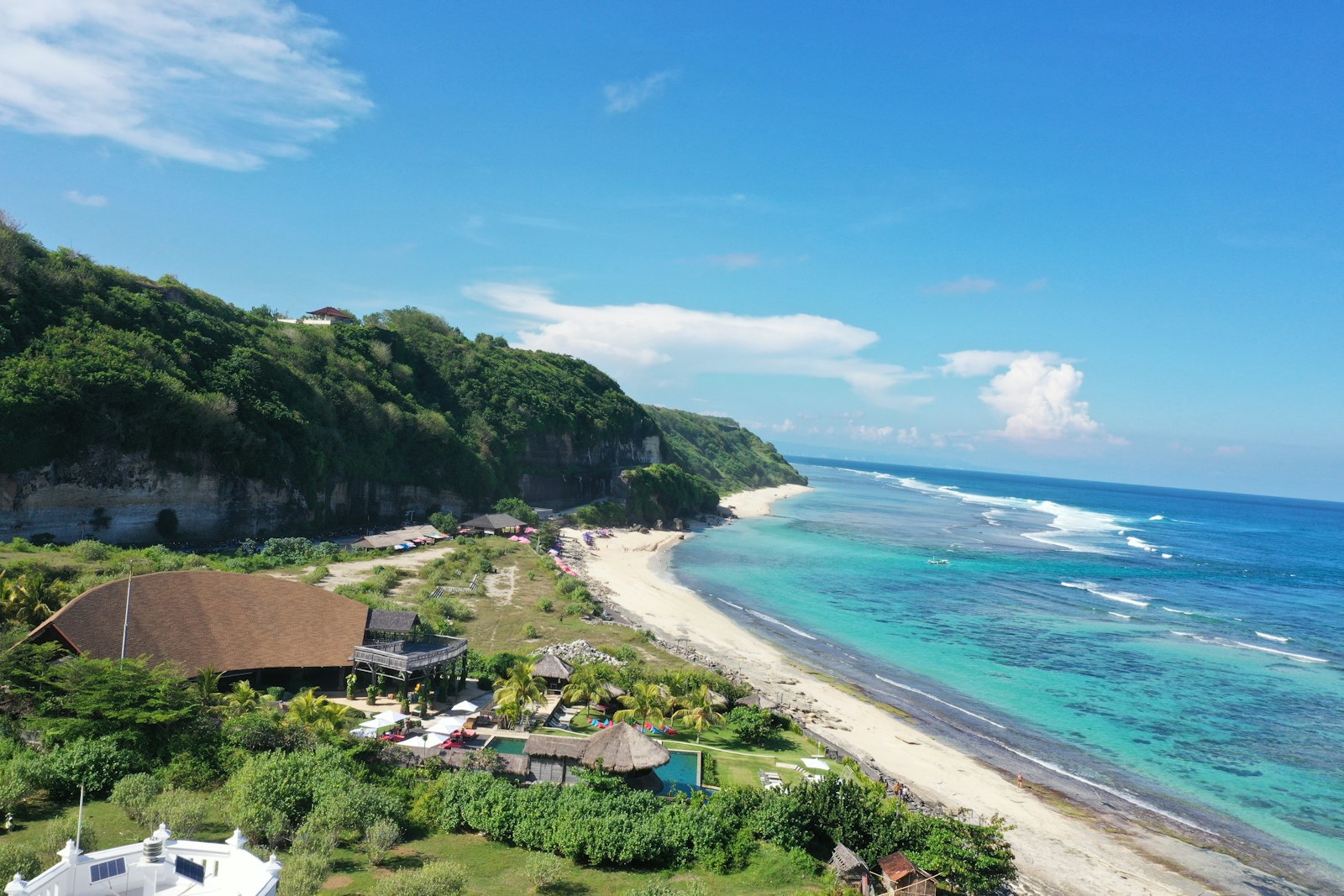
Tambolaka Airport (TMC), West Sumba Regency is the access point for most West Sumba investment activity: the beaches and clifftops near Wanokaka, the surf breaks around Kodi and the Nihi corridor, and the provincial capital Waitabula. Flights connect Tambolaka to Bali (Ngurah Rai/DPS) and Kupang (El Tari/KOE) on roughly one-hour sectors. Denpasar is the most practical hub for travellers routing from anywhere else in the world: fly into DPS, clear immigration if international, transfer to a domestic Tambolaka departure.
Umbu Mehang Kunda Airport (WGP), Waingapu, East Sumba Regency is the gateway to East Sumba: the administrative centre Waingapu, the semi-arid savanna landscapes and the tenun ikat weaving villages that attract cultural tourism. The same domestic routes apply — via Bali or Kupang — and the island’s main spine road connects the two airports, running roughly west from Waingapu to Waitabula then north to Tambolaka.
Neither airport handles international arrivals. Every foreign buyer, guest or operator flies through Bali or another Indonesian hub first. That routing adds time, cost and complexity relative to markets with direct international access — a structural constraint that is worth internalising before modelling anything about tourism demand or development viability.
Drive Time: The Figure That Matters More Than Flight Time
The one-hour flight from Bali to Tambolaka is the easy part. From the airport to the coastal and clifftop parcels that most land marketing targets, the overland transfer is approximately two hours. Roads on the main Tambolaka-to-Waitabula spine are generally paved. Beyond the spine, particularly on routes south toward the Wanokaka and Kodi coastlines where most premium investment land sits, the surface quality degrades. Graded dirt tracks, seasonal river crossings and single-lane sections are common. In the wet season — roughly November through March, with the heaviest falls in January and February — some access routes become unreliable or impassable without a high-clearance four-wheel-drive vehicle.
A brochure that describes a parcel as “one hour from Bali” is technically counting only the flight. The full door-to-door journey from Bali to a beachfront parcel in West Sumba, with a standard connection and transfer, is realistically four to six hours depending on flight timing and road conditions. For a resort guest or a prospective buyer doing site visits, that is the number that governs the experience of the asset, not the flight duration.
Before committing to a purchase, drive the actual route to the specific parcel — in the relevant season — and record your own times. A broker’s stated transfer time is often dry-season optimistic and assumes a direct route without stops. Your guests and your operational team will use the same road every week.
Why Proximity to Tambolaka Supports a Premium Narrative
Access to Tambolaka is the primary reason West Sumba commands higher asking prices than East Sumba on comparable land types. The mechanism is straightforward: West Sumba concentrates the island’s most internationally recognisable luxury tourism asset (Nihi Sumba, near Wanokaka), the best-known surf breaks (Occy’s Left and adjacent breaks in the Kodi region), and the majority of boutique eco-lodge and resort development. Those assets generate international demand for West Sumba specifically. Tambolaka is the gateway that makes West Sumba reachable at all — without it, the market would not exist in its current form.
Current asking prices for West Sumba beachfront and clifftop land sit in an indicative range of approximately IDR 22–24 million per are (100 m²), with some listings marketing hectare-scale parcels from around USD 95,000 based on available broker data. These are asking prices from individual listings, not transaction-cleared market data — Indonesia has no public land transaction database. Take them as an indicative bracket, not a price index.
Compared to Bali hotspots such as Uluwatu or Pererenan, where beachfront land is marketed at USD 400–800+ per square metre, Sumba’s West Coast is substantially cheaper at comparable coastal positions. A conservative like-for-like comparison suggests the gap is roughly 3–5 times in Bali’s favour. Marketing claims of 10–20 times cheaper are not supported by a methodical comparison of verified asking prices — treat them as promotional framing.
The airport-proximity premium within Sumba itself is real at the listing level: land closer to Tambolaka and to the established resort zones commands higher asking prices than equally scenic land in more remote sub-districts without the access. Whether that premium is sustained in a transaction — whether a buyer actually pays it, and whether a seller actually achieves it — is a separate question that the available data cannot answer, because no cleared-price database exists.
| Dimension | Tambolaka (TMC) — West Sumba | Waingapu (WGP) — East Sumba |
|---|---|---|
| Serves | Waitabula, Waikabubak, West Sumba coast | Waingapu city, East Sumba regency |
| International flights | None | None |
| Main domestic hub | Bali (DPS) or Kupang (KOE) | Bali (DPS) or Kupang (KOE) |
| Approx. flight time from Bali | ~1 hour | ~1 hour |
| Drive to main resort zones | ~2 hrs to Wanokaka/Kodi coast | Shorter to Waingapu; longer to south coast |
| Road quality to beachfront parcels | Mixed; partly paved spine, tracks beyond | Mixed; drier but fewer paved routes |
| Premium tourism investment concentration | High (Nihi corridor, surf breaks) | Lower; niche cultural and eco tourism |
| Typical asking prices (beachfront) | ~IDR 22–24m/are (indicative, listing-level) | Generally lower; fewer marketed listings |
Tambolaka vs Waingapu Access: What the Comparison Actually Tells You
The Tambolaka vs Waingapu access comparison is not simply about which airport is closer to your parcel. It is about what each gateway unlocks in terms of tourism demand, infrastructure maturity, and the buyer pool for your eventual exit.
West Sumba’s access through Tambolaka connects to the island’s established premium tourism narrative. That matters for two reasons. First, it means there is already a small but real pool of international visitors with experience of the Sumba journey — guests who flew through Bali, did the two-hour transfer, and found the experience worth repeating or telling others about. That demonstrated demand, however thin, is more bankable for a hospitality project than East Sumba’s theoretical future demand.
Second, Tambolaka access connects to a cluster of supporting services — local contractors with some exposure to international-standard construction, a modest supply chain for building materials through Waitabula, and a small community of foreign operators and investors who have navigated the permitting and land-title process locally. That knowledge base reduces the cost of making mistakes, slightly. East Sumba is earlier in that accumulation curve.
East Sumba through Waingapu offers a different proposition: lower asking prices, less competitive land acquisition environment, and landscapes — the savanna, the megalithic tomb villages, the ikat weaving tradition of the Kambera region — that attract a culturally motivated visitor profile rather than a surf-and-luxury one. For a specific type of culturally anchored eco-lodge or agritourism project, the access trade-off may be worth making. But the buyer pool for your eventual exit will be smaller, and the pathway to rental income less proven.
Neither airport represents a development shortcut. Both require the same methodical approach to land title, adat validation, infrastructure self-provision and legal structure. Access improves a project’s marketing story; it does not resolve the underlying land, infrastructure or legal challenges.
The “Upgraded Airport” Claim: Apply Scrutiny Here
Airport proximity to land value in Sumba is frequently invoked alongside a secondary claim: that “upgraded airports and better road access” have driven or will drive tourism growth and therefore appreciation. This is where disciplined reading of access claims matters most.
Tourism growth in West Sumba is real — the island is visited by more international travellers now than a decade ago, and access infrastructure has improved from the baseline that the Nihiwatu resort founders worked with in the 1990s. That is verifiable in broad terms. What is not verifiable — not in any specific government plan, tender document, budget line or published timeline that can be independently confirmed — is any particular named airport-upgrade project with a stated completion date, allocated budget or contracted scope.
If a listing agent or developer pitch deck tells you that a specific terminal expansion, runway extension or new flight route is planned for Tambolaka, ask for the source. Government aviation plans for eastern Indonesian airports exist in various planning documents, and some aspirations have been stated in regional development literature. But stated aspirations are not funded projects, and funded projects are not delivered projects, particularly in eastern Indonesia where infrastructure timelines are frequently extended. An upgrade that “is coming” in 2026 may or may not arrive in a timeframe that affects the value of a parcel you buy today.
The same applies to road claims. Better road access to West Sumba’s coastline is a genuine value driver; the question is whether a specific improvement is confirmed and funded, or whether it is a narrative recycled from the previous five years of the same pitch. Drive the road to the parcel yourself. Your direct experience of road quality in the relevant season is more reliable than any broker’s access description.
The conservative investment position: evaluate the parcel on the current access reality, not the projected one. Model your returns on what the access is today. If a road upgrade or flight increase materialises, treat it as upside — not as a baseline assumption baked into your entry price.
Ready to pressure-test an access claim on a specific parcel? Use our enquiry form or reach us on WhatsApp at 6281139414563 — we can help you think through the right questions to ask before you travel to site.
What Drive Time and Road Quality Mean for Your Specific Parcel
Airport proximity at the island level is only the first filter. For any individual parcel, the relevant access question is the one the brochure never asks: what is the road from the main spine to this specific site, and what is the realistic transfer time for a guest arriving at Tambolaka at midday in February?
West Sumba’s main road — the Waingapu–Waitabula–Tambolaka corridor — is generally paved and passable year-round. The branches off it toward beachfront and clifftop parcels are a different story. Many segments are graded earth tracks maintained, to varying degrees, by the regency or by adjacent landowners. In the wet season, sections with steep gradients or clay soils can become impassable for standard vehicles. A parcel that is twenty minutes off the spine in July can be effectively cut off in January.
What to check before you rely on any access claim:
- Visit in the wet season. If your schedule only permits dry-season visits, talk to local drivers who make the run regularly, and ask specifically about January and February conditions — not conditions “in the wet season” generically.
- GPS the actual route from Tambolaka to the parcel boundary, not to the nearest town. Track the distance and surface type, and calculate your own time estimate.
- Ask who maintains the access track. A track maintained by a single large resort adjacent to the parcel may change condition if that resort modifies its operations. A track maintained by the local village may not be maintained at all outside of peak season.
- Factor guest experience into the development model. Luxury guests who have paid for a multi-night stay arriving after two flights and a two-hour transfer are already at the edge of their tolerance for journey fatigue. An additional forty-minute rough track, in the dark, after rain, is a material part of the first impression — not a footnote to manage later.
The Adat and Title Layer That Access Does Not Resolve
Airport access and road proximity support the narrative around West Sumba land values. They do not resolve the underlying risk layer that every serious buyer must address before any deposit leaves their account.
West Sumba operates under a living customary land system rooted in kabisu (clan) structures and Marapu spiritual traditions. A parcel adjacent to a good road and within forty minutes of Tambolaka can carry unresolved kabisu claims, village-head consent gaps, or unclear title chains that sit entirely outside the BPN (national land registry) framework. A state-registered certificate verifies that the land office has recorded a right; it does not extinguish prior customary claims the community continues to recognise.
Coastal-land disputes in West Sumba — including documented conflicts in areas such as Marosi Beach — have arisen precisely in high-profile locations where the access premium inflated seller expectations and accelerated transactions without adequate community due diligence. The Marosi conflict is documented in Indonesian media and NGO land-rights monitoring; the specifics of any individual case are best read in primary sources. The pattern is worth understanding: access premium and community-land risk can occupy the same parcel simultaneously, and the access premium does not offset the risk.
Adat validation — community consultation, village-head consent, kabisu elder engagement where customary use exists — should run as a parallel track to the BPN title check, not as an afterthought once a deed has been drafted. A notary and PPAT can execute a legally valid transfer while leaving the buyer exposed to a community grievance that surfaces the following year. This is the discipline that no access story, however good, makes unnecessary.
Access as a Necessary, Not Sufficient, Value Driver
Getting to West Sumba flights is easier now than it was in 2005. The Tambolaka routing via Bali, with roughly one-hour sectors and regular scheduled services, makes the island accessible to international visitors without requiring the charter flexibility that early Nihiwatu guests needed. That accessibility is a genuine precondition for any tourism or hospitality investment.
But precondition is not the same as guarantee. Every market that has developed premium tourism had a moment when the access worked and the other conditions — infrastructure, community relations, title security, capital availability, operator quality — either came together or did not. Sumba is at an early point in that process. The access exists. The rest requires deliberate construction.
Broker claims that land prices in the Tambolaka corridor have risen by specific percentages — figures of 1,200% appreciation, or annual demand growth of 30%, appear in marketing material from some operators — have no independent transaction data behind them. They reflect asking-price optimism in an illiquid market where sellers set their own prices and no public registry records what buyers actually pay. Present them as attributed claims from the sources that make them; do not treat them as market fact. This guide does not.
For a complete picture of how access, infrastructure self-provision, title structure and community due diligence interact for a specific parcel, reach us through our enquiry form or contact us on WhatsApp at 6281139414563 or by email at bd@juaraholding.com. We can help you map the right questions before you travel to site or engage a notary.
Frequently Asked Questions
Are there direct international flights to Tambolaka Airport in West Sumba?
No. Tambolaka (TMC) operates domestic flights only. The standard routing from any international origin is to fly into Bali (Ngurah Rai/DPS), transit through the domestic terminal, and take a domestic sector to Tambolaka — roughly one hour in the air. Kupang (El Tari/KOE) is an alternative hub for travellers coming from eastern Indonesia. There are no confirmed plans for international service at Tambolaka that have been independently verified; treat any such claim as speculative until it appears in a confirmed airline schedule.
How long does it take to get from Tambolaka Airport to West Sumba resort areas?
The drive from Tambolaka to the main West Sumba resort and surf zones around Wanokaka and the Kodi coastline is approximately two hours under normal dry-season conditions. Road quality is mixed: the main Tambolaka-to-Waitabula spine is generally paved; the branches toward beachfront and clifftop parcels are partly paved and partly graded tracks of variable quality. In the wet season, access to some locations takes longer or requires a high-clearance four-wheel-drive. Verify the actual route and condition for your specific parcel before committing to any transfer-time assumption in a development or rental model.
Does proximity to Tambolaka Airport actually increase land values in West Sumba?
At the listing level, yes — parcels in West Sumba with reasonable access to Tambolaka and proximity to the established resort and surf zones carry higher asking prices than comparable land in more remote or less-connected sub-districts. Current indicative asking prices for West Sumba beachfront are in the range of IDR 22–24 million per are based on available listings. Whether those asking prices are actually achieved in transactions is a separate question that Indonesia’s absent public land-transaction database cannot answer. Access supports the narrative; it does not guarantee the price.
What is the difference in access between Tambolaka and Waingapu for investors?
Both airports serve Sumba on domestic routes via Bali or Kupang, with roughly similar flight times. The functional difference is what each gateway unlocks. Tambolaka connects to West Sumba’s established premium tourism concentration — the Nihi Sumba corridor, the main surf breaks, the majority of boutique resort development — and the higher asking-price land market that accompanies it. Waingapu connects to East Sumba, which is drier, less expensive at the listing level, and home to a different tourism profile centred on cultural and natural-landscape assets. East Sumba generally has lower asking prices partly because the tourism infrastructure and international demand are thinner; the infrastructure and adat due-diligence requirements are comparable across both regions.
Should I trust claims that airport upgrades will drive land appreciation near Tambolaka?
Treat them with caution until you can verify the source. Tourism growth has been attributed broadly to improved airport and road access in West Sumba, and that characterisation is reasonable in general terms. But no specific airport-upgrade project — with a named scope, confirmed budget, and delivery date — has been independently verified at the time of writing. Government aviation plans for eastern Indonesian infrastructure exist in various planning documents; plans and funded, completed projects are different things. Evaluate any parcel on the access infrastructure that exists today, not on an improvement that “is planned” or “should come.” If an upgrade materialises, treat it as upside on an investment you made on solid current-state fundamentals.